


SkyCourse

Air navigation, simplified

Plan, fly and navigate with total clarity.

SkyCourse brings offline moving maps, flight planning and Trio EZ Pilot autopilot navigation together — with aviation charts, weather, live traffic and terrain-aware safety tools.

Start 30 days free
Get it on Google Play AVAILABLE NOW
Download on the App Store (coming soon) IOS COMING SOON

SkyCourse runs on the Android platform today — iOS coming soon.

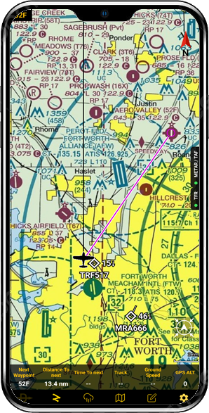
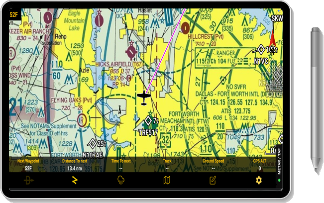
SkyCourse moving map on a phone, showing a route near Fort Worth with nearby traffic SkyCourse moving map on a tablet, showing Dallas–Fort Worth airspace with traffic and the data bar

Everything you need in the cockpit

Prepare & Navigate

  • Import GPX flight plans or create one yourself! Fly “Direct To” any waypoint in the database along a magenta course line.
  • Easy and fast course sharing between devices makes multi device operation a breeze even during flight
  • Live GPS supplies bearing, cross-track error and waypoint sequencing. With adaptive course navigation algorithm
  • HSI display that follows your route
  • Load the relevant maps directly on your device for off line navigation
  • Easy and intuitive – spend less time fiddling and more time flying
  • See your aircraft, heading line and time prediction circles. Your breadcrumb track is saved automatically as GPX after landing
  • Display multiple charts together. Auto map mode stacks downloaded charts and reveals detailed aerodrome charts when taxiing to or from the ramp
  • Find waypoints with live search and a custom, predictive keyboard

Charts and terrain

  • Official Israeli CAAI charts
  • Italy charts and airspace
  • Choose from 55 US sectional charts
  • Nationwide USA IFR Low and IFR High maps
  • 14 IFR area charts
  • Aerodrome charts for major airports, click for a complete list
  • USA charts follow the FAA 56-day cycle and updates automatically, other charts are updated upon new release
  • Buy the charts you need through Google Play and restore previous purchases

Weather and trip preparation

  • Bring weather, NOTAMs and a per-leg navigation log into your flight preparation.
  • View wind, cloud cover and precipitation across the visible map. Browse METAR and TAF tabs, including TAF decoding. In the USA also SIGMET, AIRMET and pilot reports (PIREP).
  • Live rain radar on the map, with the time of the last update
  • Display NOTAMs on the map, including NOTAM route lines for any selected time frame
  • Flight planning with wind aloft calculates wind-triangle headings, groundspeed, fuel and time for each leg, with VFR cloud-base warnings and CSV export.

Plan and file

  • File your flight plan from the app. Israel: draw your route over the published corridors, Skycourse emails the plan to the authority and pushes their reply to your phone
  • USA: your route fills in the 1800wxbrief form for you to check and file
  • Weight and balance with saved aircraft profiles: loaded and no-fuel weight and centre of gravity shown on the envelope

Traffic and safety

See live ADS-B traffic, stay connected with other SkyCourse pilots and assess terrain-limited glide range.

  • 4 independent Traffic sources for unobstructed traffic display
  • Support for ADS-B receivers, including Stratus and other GDL90 supported devices
  • TCAS-style proximate, TA and RA alerts with audible warnings and adjustable thresholds
  • Tap an aircraft to silence its alerts for formation flying
  • Location sharing throughout the SkyCourse network makes your flying safer and increases your situational awareness dramatically
  • Round Avue with your buddies in the air? Get notifications when they take off directly on your device
  • A terrain-aware glide-range ring with predicted winds compensation shows you your glide range at all times for maximum safety
  • Terrain layer and profile flight path view with vertical speed line for complete terrain elevation awareness
  • 3D view of the terrain ahead with your chart laid over it
  • Airspace alerts in the USA and Italy

Situational awareness only, not a certified collision-avoidance system.

App tier pricing

Every edition includes a free 30-day trial. Cancel anytime.

Basic

$59/ year

✓ 30-day free trial

Start 30 days free

Advance

$85/ year

✓ 30-day free trial

Start 30 days free

Pro

$109/ year

✓ 30-day free trial

Start 30 days free

Compare editions

Feature Basic Advance Pro
Moving map✓✓✓
Flight plan filing✓✓✓
Smart multi map✓✓✓
NOTAM and METAR on map✓✓✓
Terrain awareness—✓✓
Traffic—✓✓
Animated wind and rain overlay—✓✓
3D vision with AHRS—✓✓
Wear OS watch integration——✓
Flight planning with wind aloft——✓
Airspace alerts——✓
Glide range advisor——✓
1 tap course and waypoints sharing——✓
NMEA 0183 out (cable sold separately)——✓

Charts are bought separately. All features free for 30 days on a new install.

Testimonies

What pilots say after flying with SkyCourse.

"I stopped carrying a paper folder and a second app. SkyCourse handles the planning and the map in one place, and it never hesitates."
Daniel R.Instrument instructor
"The airspace alerts have saved me twice already — I get warned early enough to actually do something about it."
Sofia M.PPL student
"Downloaded the region the night before and flew a whole weekend with no signal. Nothing ever dropped out."
Tom K.Tailwheel pilot

For companies

Skycourse for fleets

Flying clubs and operators can put their tablets on one company licence with a code. A dispatcher sees the company's aircraft on a web console and can send an area to the pilots' maps.

Pilots in a fleet share their position with the company.

Contact us for a quote info@skycourse.app